It is reported that directives and requirements will come into operation on 27 November 2020. Circular issued follows.
PORT MARINE CIRCULAR No 41 OF 2020
VHF RADIO TELEPHONE REPORTING PROCEDURES FOR VESSEL MANOEUVRING WITHIN THE TRAFFIC INFORMATION AREA (TIA) IN THE EAST JOHOR STRAIT
INTRODUCTION
- This circular supersedes the Port Marine Circular No 03 of 2016 dated 19 Jan 2016.
- The directives and requirements stipulated in this circular are made pursuant to Section 43 and Section 45 of the MARITIME AND PORT AUTHORITY OF SINGAPORE ACT (CHAPTER 170 a), which will come into operation on 27 November 2020.
DEFINITIONS
- The following definitions are used only for the purpose of this circular:
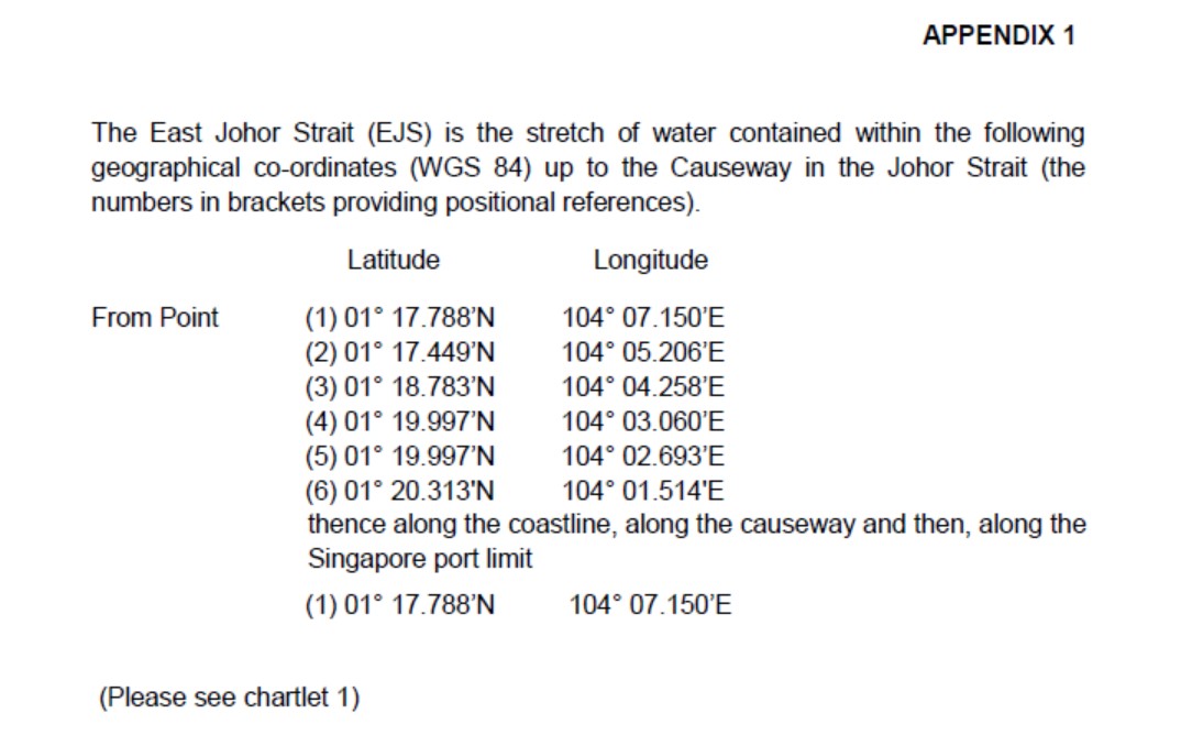
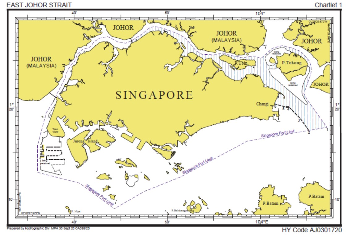
- East Johor Strait (EJS) – the stretch of water contained within the geographical co-ordinates shown in Appendix 1 up to the Causeway in Johor Strait.
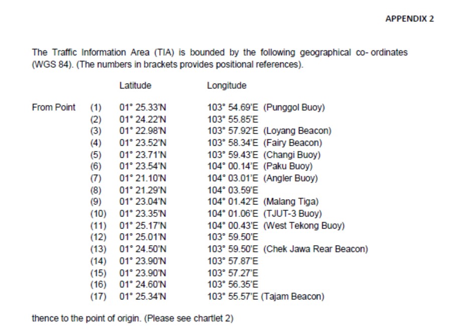
- Traffic Information Area (TIA) – the area contained within the geographical co-ordinates shown in Appendix 2.
- Height – refers to the height declared by the vessel, measured vertically from the waterline to the highest point of the vessel including its cargo, structure or equipment on board. If there are extendible structures on board, the highest point shall be the maximum height attainable by these structures when fully extended, if such extended height exceeds the verifiable with the appropriate plans or documents carried on board the vessel.
- Night Time – refer to the hours between 1900 hrs and 0630 hrs.
- Sembawang Control – the designated communication centre for EJS.
APPLICATION
- This circular shall apply to the following:
- vessel(s) of 2000 GT or more;
- vessel(s) with height exceeding 30 metres;
- tug(s) when engaged in towing or pushing, the combined GT of the tug(s) and tow(s) or vessel(s) being pushed is 2000 GT or more or when any of the tug(s) or tow’s height exceed 30 metres.
SEMBAWANG CONTROL STATION
- All movements of vessels are to be reported to Sembawang Control station. It operates on VHF Channel 21 and the reserve channel is VHF Channel 13.
- All reports made to Sembawang Control Station shall be in English. Timings shall be reported in local time following the 24-hour clock system.
- Every vessel when underway or at anchor in EJS shall maintain a continuous listening radiotelephone watch on VHF Channel 21.
NIGHT TOWING
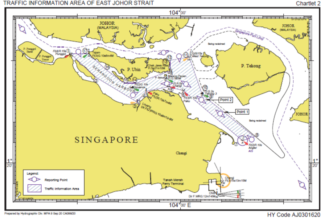
- Night towing operation is not permitted in the part of the east Johor Strait from the Causeway to Angler buoy Lat. 01° 21.10’N Long. 104° 03.01’E (WGS84).
SPEED
- The maximum speed for EJS shall not exceed 12 knots.
- The maximum speed when passing the vicinity of Sembawang Shipyard, Malaysian Shipbuilding and Engineering Yard, Pasir Gudang and Changi Sailing Club, approximate position Lat. 01° 23.6’N Long. 103° 58.7’E (WGS 84) shall not exceed 6 knots. This is to prevent the passing vessel from creating high bow waves that could cause vessel or pleasure craft to part their moorings.
RESTRICTION IN THE TRAFFIC INFORMATION AREA
- No vessel shall proceed south of the line joining CAAS Buoy 1 Lat. 01° 23.55’N Long. 103° 59.94’N (WGS 84) and CAAS Buoy 2 Lat. 01° 23.68’N Long 103° 59.60’E (WGS 84).
- No vessel is permitted to stop or anchor within the TIA. If a vessel has to stop or anchor in an emergency situation, the vessel shall report to Sembawang Control without delay.
REPORTING PROCEDURE
FORMAT OF REPORT
- Every vessel shall make the following report to and obtain clearance from Sembawang Control before entering or maneuvering within or leaving the East Johor Strait. The report shall contain the following information:
- name of vessel;
- callsign;
- present location;
- destination, i.e. the location in the port or bound for sea;
- draft;
- height;
- remarks, if any, i.e. any other relevant information on the vessel which would affect its navigation; and (h) the estimated time of arrival (ETA) at the followinglocations:
- the line joining West Tekong Buoy Lat. 01° 25.17’N Long. 104° 00.43’E (WGS 84) and the point north east of Pulau Ubin Lat. 01° 25.00’N Long. 103° 59.47’E (WGS 84) or the Longitude 103° 59.53’E (WGS 84) which extends northwards off the eastern end of Pulau Ubin.
- Point 1 Lat. 1° 22.42’N Long. 104° 01.93’E (WGS 84);
- Point 2 Lat. 01° 23.08’N Long. 104°01.02’E (WGS 84);
- Paku Buoy Lat. 01° 23.54’N Long. 104° 00.14’E (WGS 84) is abeam;
- Malang Papan Beacon Lat. 01° 24.10’N Long. 103° 59.34’E (WGS 84) is abeam; and
- Seletar Buoy Lat. 01° 26.53’N Long. 103° 52.60’E (WGS 84) is abeam;
Note: The various ETAs, referred to in paragraph 13 (h), are used for the coordination of aircraft traffic. It is important that such ETAs are accurate. The locations of the reporting points are given in Chartlet 2.
- In addition to the above, every vessel shall also report to Sembawang Control when passing the reporting points referred to in para 13(h).
UPDATING AND CONFIRMATION OF ETA
- The vessel shall update and confirm the declared ETAs referred to in paragraph 13(h) to Sembawang Control when passing the following locations:
- for Northbound or Westbound vessel, when Angler Buoy Lat. 01° 21.10’N Long. 104° 03.01’E (WGS 84) is abeam;
- for Eastbound vessel, when Punggol Buoy Lat. 01° 25.33’N Long. 103° 54.69’E (WGS 84) and again when Squance buoy Lat. 01° 23.66’N Long. 103° 57.68’E (WGS 84) are abeam;
- for Eastbound vessel entering the TIA via Nenas Channel shall confirm or update the ETA referred to in this paragraph; and (d) for Southbound vessel from Sungai Johor Lat. 01° 27.00’’N Long. 104° 01.10’E (WGS 84) when the vessel is underway.
CHANGES TO ETA
- The vessel shall monitor the declared ETAs referred to in paragraph 13 (h) and immediately report to Sembawang Control if:
- the declared ETA for Point 1 Lat. 1° 22.42’N Long. 104°01.93’E, P o i n t 2 Lat. 1° 23.08’N Long. 104° 01.02’E, Paku Buoy, Malang Papan Beacon, West Tekong Buoy or north east of Pulau Ubin differs by 2 minutes from the last declared ETA; and
- the declared ETA for Seletar Buoy differs by 15 minutes from the last declared ETA.
REMINDER
- The VHF reporting procedure stated in this circular applies only to vessels stated in paragraph 4 maneuvering within the TIA in the EJS.
- The shipping community is reminded that every vessel of 300 GT or more or tug when engaged in towing or pushing if the combined GT of the tug and tow or vessel(s) being pushed is 300 GT or more or any passenger vessel, maneuvering in port is required to report to the designated control centre as stipulated in Port Marine Circular No 07 of 2019.
CLARIFICATION
- For clarification, please contact the duty watch manager of Sembawang Control at Tel: 6481 5848 (email This email address is being protected from spambots. You need JavaScript enabled to view it.).
Source: https://safety4sea.com, MPA